Saturday, November 28, 2015

Pine Dunes Forest Preserve

The Lake County Forest Preserve District (of Illinois) opened their newest preserve this week, Pine Dunes Forest Preserve located in the northernmost section of the county in Antioch and near the Wisconsin border. The main entrance and paved parking lot is on Hunt Club Road just north of Edwards Road. A separate second entrance is located on Edwards Road just west of Hunt Club Road. Follow entry drive to grass parking area.


The preserve encompasses 867 acres of prairie, savanna and oak-hickory woodlands, as well as scenic streams, marshes, sedge meadows, vernal ponds and other wetland communities. The map below shows the 2.2 mile loop trail (yellow) and three pedestrian/bike entrances (white). The LCFPD has constructed four boardwalks to protect the fragile areas as well as three scenic overlooks for visitors to enjoy the views. The trails are open to hikers, bikers, cross country skiers, and equestrians.


Talk about having a heart for the environment. The property was formerly the McClure family homestead and featured well-maintained woodlands, wetlands, and prairie. The property is special because of its diverse topography and the fact that the former owners, Ilse and Michal McClure, consciously improved the natural features while they owned the property from 1977 to 2010, and it was the family's stated desire to preserve the property as a forest preserve that could be enjoyed for years to come by all people.


The land is described by the forest preserve district's natural resource experts as “some of the finest rolling topography found in Lake County.” Approximately 70 percent of the land is upland habitat, while the remaining 30 percent is wetland communities.


The Illinois Wildlife Action Plan, Chicago Wilderness, and the Max McGraw Wildlife Foundation have all identified the preserve's habitats as critical nesting and foraging areas for a variety of birds and other wildlife species.


Eventually, the preserve will be connected to the nearby Des Plaines River Trail and neighboring Van Patten Woods Forest Preserve, and also to the Millennium Trail.


Tuesday, November 24, 2015

Virgin Islands National Park

Virgin Islands National Park is comprised of 7,259 acres of terrestrial habitat on St. John and 5,650 acres of adjacent submerged lands, providing protection and preservation for tropical and migrating birds, fish, corals, and other marine life, as well as some 800 species of plants. The park also protects 122 acres (90%) of Hassel Island.


The park dates to about 60 years ago when Laurence Rockefeller, son of John D. Rockefeller, Jr., began acquiring land on this 20-square mile island including most of the sandy beaches of the North Shore. Laurence followed in his father's footsteps in conservation efforts as he was also instrumental in enlarging Wyoming's Grand Teton National Park as well as parks in California, Maine, and Hawaii.


In 1956, Congress passed the bill creating Virgin Islands National Park and an additional 5,000 acres were added in 1962. Hassel Island was added in 1978. Before leaving office in 2001, President Bill Clinton signed an act protecting a large area of submerged land off the island’s East End, thus creating the Coral Reef National Monument.

There are seven species of corals found in the Caribbean that are listed under the Endangered Species Act as threatened. Corals are critical to the health of the marine ecosystems and provide protection for coastal communities as well as habitats for a multitude of other species. Threats to corals include ocean warming, ocean acidification, dredging, coastal development, pollution, disease, reef fishing, damage from boats and anchors, marine debris, and aquatic invasive species.


There are no airports on St. John so you must fly to St. Thomas and travel by car or taxi to Redhook at the west end of St. Thomas. From there you can take a car barge or the people ferry to St. John.

Virgin Islands National Park contains examples of most western tropical Atlantic terrestrial, coastal, and marine ecosystems. These include various types of subtropical dry to moist forest, salt ponds, beaches, mangroves, seagrass beds, coral reefs, and algal plains. Terrestrial topography is quite dramatic with average slopes being 30 percent. The highest mountain peak plunges sharply to the sea over a distance of three quarters of a mile.

World famous Trunk Bay beach was named as one of the top 10 beaches in the world. Its underwater snorkel trail is an excellent place for beginners or anyone wanting to learn about marine life. Plaques along the trail describe the various species of fish and provide information about the coral reefs. Below is a Gliding green turtle.


Virgin Islands National Park’s hills, valleys, and beaches are breath-taking. However, within its 7,000 plus acres on the island of St. John is the complex history of civilizations - both free and enslaved - dating back more than a thousand years, all of whom utilized the land and the sea for survival.

Significant prehistoric sites are present on almost every beach and in every bay within the park. These archeological sites date from as early as 840 BC to the arrival of Columbus. There are early nomadic hunter-gatherer Archaic Period sites, followed by early chiefdom villages, then complex ceremonial sites, and all have their own burial grounds. These sites have given us a greater understanding of this Caribbean region’s pre-history as well as the religious and social development of the Taino culture that greeted Columbus.

These sites have also dramatically increased our understanding of the ancient rock art that is found throughout the Caribbean islands, such as when it was carved, why they were carved in specific areas such as at Reef Bay, their purpose, any religious meaning, and how they reflect cultural development.


After Columbus’ arrival, the Virgin Islands' became one of the first melting pots made up of many cultures from around the world. European powers competed for strategic and economic control and brought enslaved workers from Africa.

Historic landscapes and architectural remains of hundreds of structures from plantation estates are found throughout the park. Ruins include windmills, animal mills, factories, great houses, terrace walls, and warehouses. In addition to plantations, there are at least two thousand house sites that had been occupied by the enslaved workers, and also their graveyards. Below is the sugar mill at Annaberg Plantation.


Hiking is one of the most popular activities so Virgin Islands National Park provides a wide variety of hiking experiences and more than 20 trails to choose from. Some offer accessible boardwalks that meander through historic ruins or take you to a bird viewing deck on lovely salt ponds.

For the adventurous, Reef Bay Trail is the most difficult and is considered a backcountry trail as it is extremely steep and rocky. The elevation of the trail drops from about 900 feet at the trailhead to sea level in two miles, and of course the return trip is all uphill. If you attempt this trail be sure to bring bug spray, lots of water, and wear sturdy shoes.


Lind Point trails are a good choice for those only here for a day or so. They begin at the Visitor Center and wrap around the Lind Point to Honeymoon or Salomon Beach.

There are three species of lizards found on St. John. The iguana, which is not a true lizard, is vegetarian and is often found in trees. When threatened, they escape by dropping to the ground or into water. They can fall 40-50 feet to a hard surface without injuring themselves.


Tuesday, November 17, 2015

Alaska's Katmai National Park and Preserve

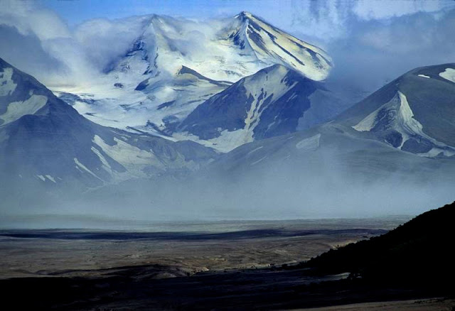
Alaska's Katmai National Park and Preserve began in 1918 as Katmai National Monument, established to protect the area around the major 1912 eruption of Novarupta which formed the Valley of Ten Thousand Smokes, a 40-square-mile 100-to-700-foot-deep pyroclastic flow. Following its designation, the monument was left undeveloped and largely unvisited until the 1950s. Below is the namesake Mt. Katmai.


The park includes as many as 18 individual volcanoes, seven of which have been active since 1900, but it also protects 9,000 years of human history as well as important habitat for sockeye salmon and thousands of brown (grizzly) bears. After a series of boundary expansions, the present national park and preserve was established in 1980 under the Alaska National Interest Lands Conservation Act. It encompasses 4,093,077 acres, most of which (3,922,000 acres) is designated wilderness area. Unlike most ANILCA parks, the legislation for Katmai did not grant subsistence hunting in the national park portion, only within the preserve.

The 1912 eruption was the largest eruption by volume in the 20th century, erupting about 3.1 cubic miles of material. Novarupta generated as many as 14 major earthquakes with magnitudes of six and seven, a level of energy release virtually unprecedented during volcanic eruptions in modern memory, and over 100 earthquakes greater than magnitude five. Following the eruption, the summit of Mount Katmai collapsed about 3,900 square feet, forming the central caldera which has filled with water.


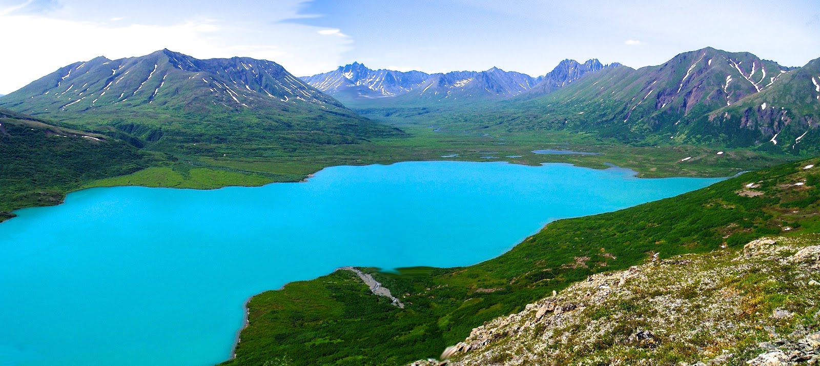
Below is the lake that has formed in the Kaguak Crater.


Initially designated because of its violent volcanic history, the monument and surrounding lands became appreciated for their abundance of sockeye salmon, the grizzly bears that fed upon them, and a wide variety of other Alaskan wildlife and marine life, including 29 mammal species, 137 bird species, 24 freshwater fish species, and four anadromous fish species (fish that migrate up rivers from the sea to spawn.) Specifically, Katmai NP has moose, gray wolves, beavers, porcupines, martens, and other mammals, including caribou which occasionally winter within the park. Marine mammals include hair seals, sea lions, and sea otters. Cetaceans include beluga whales, orcas, and gray whales.


The most important fish in the park are sockeye salmon, a mainstay for the diet of the bears, but also an important food source for bald eagles and others during the spawning runs in the park's rivers. Salmon enter the Naknek River drainage from Bristol Bay in June and July and spawn from August to October.


Katmai occupies the Pacific Ocean side of the Alaska Peninsula, south and west of Homer, south of Lake Clark National Park, and opposite Kodiak Island. The park's chief features are its 497 mile coast on Cook Inlet, the Aleutian Range with its chain of fifteen volcanic mountains across the coastal southeastern part of the park, and a series of large lakes in the flatter western part of the park.


The closest significant town is King Salmon west of the park where the park's headquarters is located, about five miles down the Naknek River from the park entrance. The Alaska Peninsula Highway runs from Naknek Lake near the entrance to King Salmon to the mouth of the river at Naknek but is not connected to the Alaska road system. Access to the park's interior is by boat on Naknek Lake. Another road runs from Brooks Camp to Three Forks which overlooks the Valley of Ten Thousand Smokes. The mountains of the Aleutian Range are about 15 miles inland and run from southwest to northeast.

The most significant volcanic event in historical times was the simultaneous eruption of Mount Katmai and Novarupta in June of 1912. Novarupta's eruption produced a pyroclastic flow that covered a nearby valley with ash as much as 300 feet thick. As the valley deposits cooled, they emitted steam from fissures and fumaroles, earning the name "Valley of Ten Thousand Smokes," a name coined by Robert Fiske Griggs who explored the volcanos' aftermath for the National Geographic Society in 1916: "The whole valley as far as the eye could reach was full of hundreds, no thousands—literally, tens of thousands—of smokes curling up from its fissured floor."


The steam vents have subsided, the valley has been eroded, and streams have cut canyons as deep as 100 feet, but often only five to ten feet wide.


The 1989 grounding of the oil tanker Exxon Valdez in Prince William Sound produced extensive contamination of the Katmai coastline. By early April, oil had reached Kenai Fjords National Park and then Cape Douglas in Katmai and points southwards in the following weeks, and 90% of the Katmai coastline had been polluted by the oil. The worst-hit areas were Cape Cjiniak and Chiniak Lagoon, Hallo Bay Beach and its lagoon, Cape Gull and Kaflia Bay, and Cape Douglas. Casualties in birds alone were estimated at 8,400 dead birds. Work resumed in 1990 to catch the last oil, with smaller efforts later in 1990s.

Weather at Katmai is variable, though reliably rainy or drizzly. Summer high temperatures average about 63 F. and winter lows range between −4 and 40. Fall is somewhat drier than the rest of the year and warm days can occur year round. Rainfall is heaviest near the coast with up to 60 inches, and lighter to the west.

Unlike most national parks in the United States, Katmai is almost exclusively accessed by plane or boat. You can not drive to Katmai, Brooks Camp, or King Salmon from Anchorage, Alaska. Most destinations in Katmai National Park Preserve are directly accessed via air taxi flights from Anchorage, Dillingham, Homer, King Salmon, Kodiak, and other nearby Alaska towns and villages.

The Pacific coast of Katmai offers a combination of amazing scenery, wilderness, and wildlife viewing opportunities. Most people who visit this area of the park go to watch bears, but there are many opportunities for sport fishing and wilderness trekking too.

Situated at the mouth of the Brooks River and the shore of Naknek Lake, Brooks Camp attracts people from all over the world to enjoy world-class fishing and learn about the long human history of the area. It is also a starting point for many backcountry adventures. Daily bus tours from Brooks Camp provide easy access to the geologic splendor of the Valley of Ten Thousand Smokes, site of the largest volcanic eruption of the 20th century.

From June 1 to September 18, the National Park Service operates a visitor center, ranger station, campground, and auditorium with daily ranger-led programs. The park concessioner, Katmailand, Inc. provides additional services and amenities including meals and lodging at Brooks Lodge.


The world's largest run of sockeye salmon occurs in Bristol Bay, Alaska, each summer. Part of that salmon run moves into Katmai National Park and Preserve through the Naknek and Alagnak rivers. In July and September, bears are everywhere at Brooks Camp. They can be found walking trails, fishing in the river, and even napping on the beach. During July, many bears can be seen fishing at Brooks Falls which is about 1.2 miles from the Brooks Camp Visitor Center. In September, most bears are seen at the mouth of the Brooks River. 


There are three viewing platforms located in Brooks Camp along the south side of Brooks River. The Falls Platform is located immediately adjacent to Brooks Falls, the Riffles Platform is located about 100 yards downstream of Brooks Falls, and the Lower River Platform is at the mouth of the Brooks River near Brooks Lodge.


The Falls Platform has a limited capacity of 40 people. When the Falls Platform is at maximum capacity, rangers maintain a waiting list and everyone is limited to one hour at a time on the platform. 


This system helps to provide equal access to the Falls Platform during peak days of visitation. If you visit Brooks Camp in July, expect crowded conditions at Brooks Falls when sights as seen below are common.


Thursday, November 12, 2015

Alaska's Gates of the Arctic National Park

Alaska's Gates of the Arctic National Park lies north of the Arctic Circle and is an unusual national park because it offers visitors no roads, no trails, no established campsites, and no visitor center. It was created in 1980 to protect 8.4 million acres and maintain its wild and undeveloped character, provide opportunities to experience solitude, protect its environmental integrity, and offer wilderness recreation. Fish and wildlife, arctic habitats, cultural resources, and traditional subsistence uses are also protected. Together with neighboring Noatak National Preserve (6.5 million acres) and Kobuk Valley National Park (1.7 million acres), Gates of the Arctic comprises part of one of the world's largest contiguous protected areas.

The park's name came from legendary wilderness advocate Robert Marshall who traveled the North Fork Koyukuk country frequently from 1929 to 1939. Marshall called two peaks, Frigid Crags and Boreal Mountain, the "gates" through which one traveled from Alaska's central Brooks Range into the far north Arctic.


The park and preserve contains tundra plains, mountain ridges and ranges, wild scenic rivers, forests, glacially formed lakes, arctic and subarctic climates, and well over 10,000 years of human history.


In fact, humans have lived on and off the land in Gates of the Arctic National Park and Preserve for more than 12,500 years. Nomadic hunters and gatherers traveled between the mountains' forested southern slopes and the Arctic Coast. Now their descendants, living in ten small communities with about 1,500 residents depend upon and use park and preserve resources for their subsistence lifestyle and thus maintain their cultural traditions. A Nunamiut Inupiat village called Anaktuvuk Pass lies inside the park.

The earliest people in the area of the Brooks Range were among the first to cross the Bering Land Bridge from Asia in the migrations that over time populated the Americas. Although humans have occupied this area for thousands of years, little evidence remains to provide clues about their lifestyles, habits, and identities. While the archeological evidence is limited, 800 archeological sites have been identified throughout the park which provide some clues about those who lived here.

As early as 11,500 years ago, peoples of the Paleoarctic tradition subsisted by hunting in small, mobile groups. Remnants of glacial ice would have dotted the valleys while these peoples moved throughout the land in harmonious rhythms with the seasons. The Paleo-Eskimos, the ancient ancestors of modern Eskimos, appeared around 4,500 years ago.

More broadly, these people are part of the Arctic Small Tool Tradition which includes the Denbigh, Choris, Norton, and Ipiutak traditions. These people made finely crafted miniature tools and successfully utilized arctic coastal resources, including sea mammals and caribou.


Gates of the Arctic is a wilderness park with no roads or trails so visitors must fly or hike into the park. Access to the park begins in Fairbanks, Alaska, which has several small airlines that provide daily flights into the gateway communities of Bettles, Anaktuvuk Pass, and Coldfoot, using small aircraft equipped with floats or tundra tires.

Another option for accessing the park is to hike in from the Dalton Highway or from the village of Anaktuvuk Pass. There are no trails into the park and preserve from any location, and river crossings are necessary from both Anaktuvuk Pass and the Dalton Highway.

In 2004, I took a flight from Fairbanks to Coldfoot, 55 miles north of the Arctic Circle, where a van and guide picked us up and drove us back to Fairbanks on the Dalton Highway, also known as the haul road used to build the adjacent Trans-Alaska Pipeline. At this point we were on the eastern edge of the Brooks Range and Gates of the Arctic National Park.


Weather rules in the wilderness, so visitors need to be prepared for all types of conditions. Rain and snowmelt can cause rivers to rise, making some routes impassable. Visitors should have enough food to stay extra days in the park and try to have flexible travel plans in case flights into the park are delayed.


The terrain is beyond challenging Since there are no established trails but plenty of dense vegetation, clumps of grassy tussocks, boggy ground, and frequent stream and river crossings, you can only progress slowly across the landscape, with six miles being a good day's progress by even the most experienced hikers.


There are no established services within the park boundaries and only limited means of communication to contact anyone for assistance. Cell phones don’t work here. Visitors to the park should be proficient in outdoor survival skills and be prepared to care for their own life if an emergency arises.


If visitors are not proficient in wilderness back country skills, they should contact an outfitter, guide service, or air taxi operator for assistance. For those visitors who don’t have the time or the backcountry skills to mount an expedition into the park, there are other options. Local air taxis provide flight-seeing trips, day trips, and overnight campouts at remote locations. Imagine a day spent fishing at an alpine lake, or watching the caribou up in the northern valleys, or sitting alongside a wild river listening to the wind in the boreal forest.


Few landmarks bear names on topographic maps here. Wind, water, temperature, and glacial and tectonic actions sculpted wildly varied landscapes in this east-west trending part of the Rocky Mountains. Southerly foothills precede mountains rising to elevations of 4,000 feet that culminate in limestone or granite peaks over 7,000 feet. Then the ranks reverse at the Arctic Divide and lead down to Tundra that stretches to the Arctic Ocean. Six national wild rivers -- Alatna, John, Kobuk, Noatak, North Fork Koyukuk, and Tinayguk -- as well as other waterways cross the park.


From November to March, most activity ceases while -20ºF to -50ºF temperatures persist. The dry interior climate sees little snow, but it can get below freezing and snow during any month, even in July. As the sun starts its warming in March, dogsledders come out. Backpackers and river runners arrive in mid-June as the rivers become free of ice. Winter is long and summer is active. Plants and animals move through life cycles quickly before winter again sets in.


Friday, November 6, 2015

Hawai'i Volcanoes National Park

Hawai'i Volcanoes National Park consists of 333,086 acres of constantly changing environments including the summits and rift zones of two of the world’s most active volcanoes, Mauna Loa and Kīlauea, as well as the surrounding seven ecological zones -- seacoast, lowland, mid-elevation woodland, rain forest, upland forest, subalpine, and alpine. All are the result of at least 70 million years of volcanism, migration, and evolution.

Five volcanoes make up the island of Hawai'i -- Kohala, Mauna Kea, Hualalai, Mauna Loa, and Kilauea. Volcanoes that will never erupt again are considered extinct. Dormant volcanoes have not erupted in the last 200 years but probably will erupt again. Active volcanoes have erupted in the last 200 years.


Kohala, the oldest volcano on this island, last erupted about 60,000 years ago and is considered extinct. Mauna Kea last erupted 3,600 years ago and is dormant. Hualalai erupted seven times in the last 2,100 years with its latest eruptions in 1800 and 1801. Mauna Loa last erupted in 1984 and sent flows towards Hilo. Kilauea (seen below) has been erupting since 1983.


Kilauea's eruption has been continuous since 1983 and its output of lava is so prodigious that it would be about 20 miles in depth if its outflow of lava wasn't primarily being transported by lava tubes to the ocean where it fragments and adds layers to the below-water flank of the volcano. Some of its lava in the Kamoamoa area is about 15 feet deep where it first crossed the road. Lava from the Kupaianaha eruption is about 75 feet deep at Queens Bath, 50 to 75 feet feet deep in Kalapana, and 45 feet deep near the sea cliff at mid-flow.


Since 1983, about 500 acres of new land has been added to the island. In contrast to explosive volcanoes like Mt. St. Helen, the eruptions of Kīlauea and Mauna Loa are more fluid and less gaseous, more like fiery fountains and rivers of molden lava. The currently active vent is 15 miles from the summit and six miles above the coast and has destroyed 187 homes, the Wahaula visitors center, the Royal Gardens Community Center, the Mauna Kea Congregational Church, and the Kalapana Drive-in. The current eruption rate of Kilauea volcano is 250,000 to 650,000 cubic yards every day, enough to cover the floor of the caldera with a thin layer of lava daily or resurface a 20-mile-long two-lane road such as the Chain of Craters Road every day. The bus in the photo below demonstrates what lava did in the 1980s when Kilauea's eruption hit the community of Kalapana.


Lōʻihi Seamount is an active submarine volcano on the seafloor south of Kilauea about 18 miles from shore and 3,178 feet below sea level. It will probably not rise up to sea level for 250,000 years or more.

Volcanoes are prodigious land builders and have created the entire Hawaiian Island chain. Kīlauea and Mauna Loa, two of the world's most active volcanoes, are still adding to the island of Hawaiʻi. In fact, Mauna Loa is the most massive mountain on Earth, occupying an estimated volume of 19,999 cubic miles. The current summit of Mauna Loa stands about 56,000 feet above the depressed sea floor, more than 27,000 feet higher than Mount Everest.

These flows, added layer upon layer, produced a barren volcanic landscape that served as a foundation for life. Hundreds of species of plants and animals found their way across the vast Pacific Ocean on wind, water, and the wings of birds. A few survived, adapted, and prospered during this time of isolation making sections of verdant greenery as on the Sandalwood Trail shown below.


Created to preserve the natural setting of Kīlauea and Mauna Loa, the park is also a refuge for the island's native plants and animals and a link to its human past. Park managers and scientists work to protect the resources and promote understanding and appreciation of the park visitors. Research by scientists at the Hawaiian Volcano Observatory makes Kīlauea one of the best understood volcanoes in the world, shedding light on the birth of the Hawaiian Islands and even the beginnings of planet Earth. Each eruption is a reminder of the power of natural processes to change the air we breath, the ground we walk on, and the sea that surrounds this volcanic island.

The island's multitude of landscapes serve as a refuge for a wide variety of unusual and endangered creatures, including the nēnē (Hawaiian Goose), ope‘ape‘a (Hawaiian hoary bat), happyface spiders, carnivorous caterpillars, honeycreepers.

If you have only one to three hours, you can explore the summit of Kīlauea volcano via an 11-mile road that encircles the summit caldera, passes through desert and lush tropical rain forest, traverses the caldera floor, and provides access to well-marked scenic stops and short walks.

If you have four to five hours, you may also explore the East Rift and coastal area of the park via Chain of Craters Road which descends 3,700 feet in 20 miles and ends where a 2003 lava flow crossed the road. Lava flow activity is always changing, so check at the Kīlauea Visitor Center for the most current information. Pullouts and overlooks along Crater Rim Drive and Chain of Craters Road offer panoramic views of the park. (Click to enlarge map.)


Hikers will find that the park offers over 150 miles of trails ranging in elevation from sea level to 13,667 feet. There can even be snow on Mauna Loa’s summit during the winter. With over half of the park designated as wilderness, there are numerous opportunities for solitude, observation of dark night skies, and access to locations that allow you to experience life on active volcanoes.


Large volumes of lava move in lava tubes beneath the hardened surface of recent flows. Skylights form when the roof of a lava tube collapses, revealing the molten lava flowing like a river within the tube. Rocks that are moving upward in the mantle beneath Hawai`i begin to melt about 40 to 60 miles in depth. The molten rock is called magma and it rises because of its relatively low density. The magma "ponds" in a reservoir 1 to 4 miles beneath the summit but can follow fractures up to the crater and produce a summit eruption. During the current eruption, the magma has followed a zone of weakness, the East Rift Zone.

Bicycles are allowed on all roads open to automobile traffic and on some trails.  A Bike Guide is available at the Kīlauea Visitor center or online at www.nps.gov/havo/planyourvisit/brochures.htm. In Hawai‘i, bicycles are subject to the same rules as automobiles. Bicycles are not available for rent in the park.


Sunday, November 1, 2015

Millennium Trail's Wilson Road Underpass Is Open!

The Lake County Forest Preserve District (Illinois) has connected two more sections of its Millennium Trail with the completion of this underpass and the half-mile paved trail connection through Marl Flat Forest Preserve and the subdivision on Litchfield Drive. That creates an 18 mile a The red oval shows the existing trail as it passes alongside the nursery


Here's the underpass as you approach Wilson Road from the Marl Flat parking lot on Fish Lake Road heading east...


...and here's the view as you exit the underpass...


You then approach the townhouse development as you cross Litchfield Drive, at which point you are on the trail segment that was opened a few years ago.


You pass between two retention ponds, pass some more townhouses, turn east again and pass homes on your left and a nursery on your right...


...head through a woodlot and pass Fort Hill Creek...


...and you'll then hit the  high-voltage power corridor and its large hills. After crossing Nippersink Road, you'll hit another hill and then finish at the disc golf course in Fairfield Park on Fairfield Road.