Monday, August 31, 2015

Alaska Railroad

The Alaska Railroad is a working railroad, with tourism and passenger service only a part of its revenue, and freight being its main revenue source. It runs north from Mile 0 in Seward to Anchorage at Mile 114, Denali National Park at Mile 347, and ends at Mile 470 in Fairbanks, with spurs to Whittier, Palmer, and Eielson Base. It is also one of America's last flag stop trains, allowing passengers to get on and off anywhere along the 55 mile wilderness stretch between Talkeetna and Hurricane to hike, fish, camp, or reach a remote cabin.


Construction of the railroad took eight years and was completed by the federal government in 1923. The State of Alaska bought it from the federal government in 1985. 


The photo below was taken from the train window as we followed Turnagain Arm south from Anchorage. The tracks used to be up against the mountainside, but frequent avalanches necessitated the relocation of the tracks and highway closer to the water.


I rode the train for one of is numerous excursions -- rafting Spencer Glacier and the Placer River. We first rode to the town of Whittier, and we then re-boarded the train and traveled to the Portage area where we had a short bus ride to the raft launch. The raft trip ended back at the train as seen below.


Interiors are spacious and the conductor was knowledgeable and kept us well-informed, even to the appearance of Dall sheep as seen in the second photo below.


This shot was also taken from the train and shows Dall sheep on the mountainside above the tracks and highway. One of the largest users of the train are the cruise ships which arrive in Whittier or Seward and then put their passengers onto the train for transit to Anchorage, Denali, Fairbanks, and elsewhere.


Along the train tracks, we passed the "Ghost Forest," created by the devastating 1964 earthquake. Before the quake, this land was above sea level and the forest thrived, but the quake caused the land to sink eight feet, the sea inundated the area, and it became a salt marsh, and since salt is a preservative, the trees remain petrified -- intact, supported by the three feet of silt deposits left by the surge tide. The ocean is a mere 100 feet away on the other side of the tracks.  I also saw this area again as I biked the Girdwood Bike Trail.


Alaska's White Pass and Yukon Route

The narrow gauge White Pass and Yukon Route Railroad climbs nearly 3000 feet from sea level to White Pass Summit in 20 miles with grades up to 3.9%. It was built from 1898 to 1900 to serve the Klondike Gold Rush and was the northernmost railroad in the Western Hemishere. Thirty thousand men worked on the route and used 450 tons of explosives (black powder) to construct the 110 miles of track, 2 tunnels, and numerous trestles and bridges. It suspended operations in 1982 when the Yukon's mining industry collapsed but reopened in 1988 as a scenic tourist operation. In 2012 it carried 370,000 passengers, predominantly from cruise ship excursions.

Here's a brief video I made of the train ride. It begins with a few shots of Skagway and around the 1:30 mark shows the trail station and then the trip up the mountain, including the voice of the train employee explaining what we were seeing.


Below is our train...


Notice how the train was heated in the winter...


The Steel Cantilever Bridge, the tallest in the world when built, is no longer used but is often photographed. The White Pass and Yukon Rail was designated one of only 36 world civil engineering marvels in 1994 due to the many hazardous obstacles that construction had to overcome. During World War II, the railroad was the chief supplier for construction of the Alaska Highway. In 1954 they changed to diesel electric motive power. 1955, the route pioneered the inter-modal "Container Route" and in 1988 began service as a tourist attraction.


This photo from the train's brochure shows the perspective of the train on the ledge as it approaches a trestle and then Tunnel Mountain.


Below are some photos I shot as our train rolled through the train yard...


Sunday, August 30, 2015

Biking Anchorage's Tony Knowles Coastal Trail

Anchorage, Alaska, has several dedicated bike trails as well as roadways with bike lanes. This map shows the Tony Knowles Coastal Trail following the shore of Cook Inlet and Knik Arm along the left side of this map, and the Chester Creek Trail, the greenbelt area starting at the Knowles Trail about an inch from the top of the photo and heading to the right. I was also able to ride the Gird-to-Bird Trail south of town.


This 11 mile trail is named for the former governor of Alaska and former mayor of Anchorage, Tony Knowles, who was instrumental in the creation of this trail. The downtown is seen in this photo as the trail approaches the intersection with the Chester Creek Trail, and beyond that, the end of the trail near downtown at 2nd Street.


The trail passes through many forested sections, offers occasional vantages of the water, goes uphill to follow a bluff line and across the property of Anchorage International Airport, and then ends at Kincaid Park, a cross country skiing paradise, which has a myriad of uphill/downhill trails open to mountain biking. The six foot wide paved trail in is decent shape though there are frost heaves on occasion.


It also passes through Earthquake Park which commemorates the 1964 earthquake with a sculpture and various information signs.


Biking Anchorage's Girdwood Trail

Anchorage, Alaska's, Girdwood Trail runs from Girdwood to Bird Point (hence its nickname, "Bird to Gird").  It has since been extended to Indian.

The 9.6 earthquake of 1964 was the second largest in recorded history and lowered the ground here eight feet, putting the forest that was here below the high tide line of Turnagain Arm and flooding the spruce forest with saltwater, killing all the trees. But since salt is the best preservative, the trees remain intact, supported by the three feet of silt deposits that were left by the tide. The area is now called the "Ghost forest."


No, this is not Anchorage's self-defense system! This 105 MM recoilless rifle (M27A1) pictured below was used to relieve the snow load before potential avalanches could crash down the mountain and destroy the Seward Highway and the Alaska Railroad tracks at its base. Ultimately, the highway and tracks were moved west to the shore of Turnagain Arm to prevent avalanches from blocking them, and the old road was turned into the bike trail.


Here the trail has risen onto a shelf above the rerouted highway, giving good vantage points to the sea. There is an elevation gain of 275 feet on the trail. Interpretive signs, restrooms, and even free telescopes are placed along the trail. An addition to the bike trail was under construction when I biked here which will add 3.5 miles and connect it to another segment in Fall, 2004, creating a 13 mile trail.


Biking Anchorage's Chester Creek Trail

Anchorage, Alaska's Chester Creek Trail branches from the Coastal Trail and follows Chester Creek, passing through several parks and forested areas, then circles around Goose Lake to the campuses of the University of Alaska -- Anchorage and Alaska Pacific University, around Northern Lights Boulevard, and UAA Drive.


The trail crosses the creek several times and the forest areas are home to a number of deer which I saw. There was quite a bit of traffic on the trail the day I biked it, and other than the expected frost heaves, the surface was in good condition.


Notice the lights illuminating the path! You don't see that on many municipal trails, but I guess with so many hours of winter darkness, it is to be expected.


Biking Juneau, Alaska's Clear Water Creek Trail

I was camping at the Forest Service's Mendenhall Lake Campground and discovered this trail as I ventured out of the campground. The trail can be accessed at the end of River Road off of Back Loop Mendenhall Road. The trail is only 2.5 miles long but runs through a lovely old fern-filled forest and parallels Mendenhall River. The official name of the trail is Kaxdegoowu Heen Dei (Clear Water Creek Trail).


The photo below shows Mendenhall Glacier in the distance and the mountains towering over it, with red fireweed plants in the foreground. You can also access the trail on Egan Road, just north of Mendenhall Loop Road by Industrial Avenue (which is where this photo was taken). Though the trail is very short, it connects with the Mendenhall Loop Bike route which in some places is a wide, paved path near the road, and at other places is a wide shoulder marked for bikes. This in turn connects with Egan Road/Glacier Highway Bike Path which can take you all the way to downtown Juneau.


Driving the Alaska Highway (Al-Can)


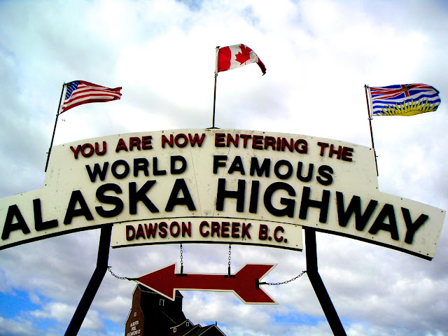
This is the starting point of the famous Alaska Highway in Dawson Creek, British Columbia. The paved road runs 1523 miles through Canada (hence the name Al-Can Highway) by way of the Yukon Territory to Fairbanks. Built in 1942 during World War II in 8 months to provide road access to Alaska where an invasion was thought possible, the then dirt road required 17,000 workers laboring in extreme conditions ranging from 90 degrees to 70 below zero, and tackling tough terrain requiring 133 bridges.


<


The scenery is always interesting and often breathtaking. Most of the highway is two lane and speed limits range from 45 to 60 mph, but many sections are hilly, curvy, and perhaps in need of repair, so caution is always required. Frost heaves create roller coaster dips and rises, and shoulders can be narrow or non-existent in places. Numerous sections were under construction in 2004 to straighten curves and make other improvements. All in all, the roadway is not a problem to drive, as long as you don't treat it as a superhighway. Slow down, drive cautiously, and enjoy the scenery and wildlife.


They aren't kidding! Within a quarter mile of this sign...


...I came upon this caribou (reindeer is the term for them when they are domesticated) smack in the middle of the road, and I must have seen several dozen as I traveled the highway. But caribou were not the only animals observed from the road, as seen below.


Deer, bison, big horn sheep, and mountain goats were frequent sights, especially in the Yukon. In addition, I saw a black bear in the middle of the highway from a hundred feet away, but it was 40 feet up the hillside by the time I reached that section of road and all I got was a photo of its rear end scampering up the slope.


How about a few more scenery shots?


On my trip to Alaska, I took the Alaska Ferry to Skagway, crossed over the Al-Can traveling north on the Klondike Highway heading to Dawson City in the Yukon (knowing I'd be on the Al-Can on my drive back to Chicago in two months.) One reason: The Klondike Highway is also called the "Top of the World" Highway. The second reason: For all you fellow English teachers or literature buffs, the reason is shown in the next two photos...the cabin of Robert Service...


...and a block away, also on 8th Avenue, the cabin of Jack London...


And then you reach Fairbanks, Alaska. It's an extraordinary drive through majestic scenery, and I recommend it highly!


Saturday, August 29, 2015

Canoeing Utah's Green River (2006)

We put in just a couple miles downriver from Green River State Park at Crystal Geyser, river mile 115.5, , a sporadic geyser created by the unsuccessful drilling of an oil well. The well head pipe can be seen in the upper middle of this photo next to the man. Constant water bubbles up there and at times water erupts from the pipe. I particularly liked the artistic creation of travertine patterns it has created as the water runs down to the river.


The first miles displayed low cliffs with desert terrain atop. The Bureau of Land Management controls much of the land down to Canyonlands NP, which is operated by the National Park Service. However, there is some private land along the river, including some farming operations which utilize the river water to grow melons. The photo below shows Gerry in the kayak and Greg in the canoe.


But soon the walls rise and the red rock dominates. The water carries the silt from the rocks and becomes more and more brownish-red as you progress down the river.


This is a small section of Registry Rock in Labyrinth Canyon which has "signatures" of many of the earliest travelers here (and some more recent ones.)


Later in our nine day paddle, we had several storms, one of which is about to hit us in the photo below as we relax in camp. After these storms, much sediment was flowing along with us, but our first days had clear blue skies and warm temps, often in the 90's (beginning of September.) Blue heron were our daily companions and we saw evidence of river beaver. Swallow mud nests are abundant in grottoes and rock overhangs. Uranium mining still exists, though reduced from past amounts.


One thing I was not prepared for was the ubiquitous mud on every shoreline, often deep enough to bury your leg up to your knee and suck your footwear off. This Utah mud is worse than the Mississippi River mud I encountered kayaking there but is cleaner. Our assistant guide, Quock, and 12 year old Austin, played in the mud often and sometimes were joined by his sister, Anna, and Greg. The river drops about a foot and a half per mile and generally moves at about 3 miles per hour.


A short climb rewards one with fantastic panoramic vistas in all directions and reveals the desert terrain atop these cliffs, markedly different from the verdant riparian environment alongside the river. At river level, willows and occasional cottonwood trees provide welcome shade to paddlers, as do the invasive tamarisk which are crowding out the indigenous flora. It is said that each tamarisk sucks 15 gallons of water from the river every day, water thereby unavailable for agricultural and human needs. Beginning at Mineral Bottom (where a ranger may check your river permit) you enter Stillwater Canyon.


The cliff dwellings and granaries are a "must see" on this trip and one of the highlights for me. Here a short climb brought us to the structures seen halfway up to the mesa. and climbing a bit higher put us atop Turk's Mesa where the Anasazi (500-1275 AD) used the abundant flint rocks to manufacture arrowheads. Large rocks and bits of shard cover the huge mesa and make for interesting study.


Here Donna, Greg, and Jan sit as Rich stands.


The paddle ended here at the confluence with the Colorado River (river mile 0) in Canyonlands National Park, where we were picked up by our outfitter, Tex's Riverways out of Moab, Utah. They loaded our gear and then jet boated us up the Colorado River 47 miles at 27 mph, utilizing the boat's dual 460 HP jet engines. It was quite a ride with magnificent scenery the entire way up Meander Canyon.

I loved this trip so much that I repeated it in 2008 with Greg. And both times, while here at The Confluence with the Colorado River, I've wanted to make the right turn and continue through Cataract Canyon just like John Wesley Powell did. But Cataract Canyon is class IV and V rapids and not for canoes! Well, in 2010 I had my chance with the Sierra Club and the photos and video are here.


====================================


The intrepid adventurers :

Austin (on sand in yellow)
front row: Virginia, Donna, Anna, Gerry, Rick
back row: Jan, Jim, Chuck, Greg (our guide), Quock (assistant guide)


Guide Greg Pflug's offered this trip through his adventure company, Adventures in Florida.