Thursday, September 30, 2010

Hiking Upper Antelope Slot Canyon

Antelope Canyon, located on Navajo land near Page, Arizona, is the most-visited and most-photographed slot canyon in the American Southwest. It includes two separate photogenic slot canyon sections referred to individually as Upper Antelope Canyon or The Crack, and Lower Antelope Canyon or The Corkscrew. 

This visit requires a ride in a "Shake and Bake" truck...


... up the dry creek bed to the entrance of the canyon...


A long time ago, herds of pronghorn antelope roamed freely in Antelope Canyon, which explains the canyon's name. To older Navajos, entering a place like Antelope Canyon was like entering a cathedral and they would pause before going in to be in the right form of mind. This would also allow them to leave with an uplifted feeling of what Mother Nature has to offer, and to be in harmony with something greater than themselves. It was and still remains a spiritual experience.


Antelope Canyon is one of the most breathtaking and tranquil places on earth. Gently carved from the Navajo sandstone over the course of countless millenniums, the slot canyons are majestic and narrow passages, just enough space for a small group to walk the sandy floor, and for the occasional shafts of sunlight to shine down from above as I captured in this photo...


The Navajo name for Upper Antelope Canyon is Tse' bighanilini, which means "the place where water runs through rocks." Upper Antelope is at about 4,000 feet elevation and the canyon walls rise 120 feet above the stream bed. Lower Antelope Canyon is Hasdestwazi, or "spiral rock arches." Both are located within the LeChee Chapter of the Navajo Nation.


Both canyons contain the hidden "slots" carved from the swirling sandstone, and both drain from the south into Lake Powell, once the Colorado River. The canyons are so narrow in places that one can stretch out his or her arms and touch both sides. Though dry most of the year, Antelope Canyon runs and sometimes floods with water after rains. It is the water, slowly wearing away the sandstone grain by grain, that has formed the beautiful and graceful curves in the rock. Wind has also played a role in sculpting this fantastic canyon.


You must have an authorized Navajo guide to tour the Upper and Lower areas of Antelope Canyon.

Lower Antelope Canyon has a completely different appeal -- more adventurous because you descend into it on ladders/stairs and feel more like a tall cave. Here's my report on Lower Antelope Canyon.

Wednesday, September 29, 2010

Glen Canyon Dam

The Glen Canyon Dam is the second largest dam on the Colorado River and is located at Page, Arizona. Its main purposes include generating electrical power, storing water for the arid southwestern, and providing water recreation opportunities. The dam generates an average of 451 megawatts representing 6% of the total electricity generated in Arizona and 13% of the electricity generated in Utah. Damming the Colorado River created the large reservoir called Lake Powell, the second largest man-made reservoir in the United States after Lake Mead at the other end of the Grand Canyon.


The tour of the dam costs $5 and lasts about 45 minutes. Below is a "runner" recently removed from service when replaced by a newer, more efficient model. The runners are what rotate as the water surges through them, causing the turbines to rotate and generate electricity. There are 8 turbines, each with a runner. Notice the Glen Canyon bridge high above in the background.


Here's another view of the bridge overhead, taken from the generator level. It was interesting to learn that the bridge was built first. Otherwise, workers and equipment would have had to drive over 200 miles to get to the other side. The bridge was fully constructed in California, then disassembled, and half driven to each side of the canyon for re-assembly.


Concrete placement for the dam ran 24 hours a day for three years -- over 5 million cubic yards were mixed in a 21 story facility on site. That's enough concrete to pave a four lane highway from Phoenix to Chicago! Then it took 3 years to install the turbines and generators and 17 years to fill Lake Powell to full-pool level.

Here's the turbine room with its 8 generators, four of which were running when we toured. Each generator's shaft weights 40 tons and the water pressure turns each shaft at 150 rpm, generating 200,000 horsepower. That represents 15,000,000 gallons of water per minute when all 8 generators are operating! 1.5 million users receive their energy from this dam, which has an estimated life of 300 to 500 years.


The dam was built by the Bureau of Reclamation and has already more than paid for itself with its 1.5 billion in revenues. All the expenses of the Bureau of Reclamation are paid by the electricity revenues generated each year, so no taxpayer funds are required.

Monday, September 27, 2010

Biking Page, Arizona's Rimview Trail

Page, Arizona's Rimview Trail could also be called the "Just below the rim trail." The city is perched upon a mesa-top, and the trail runs along a shelf about 20 feet below the mesa, sometimes only inches from the drop-off which could be 20 feet in places or a hundred feet elsewhere. I've biked the 11 mile trail the last three times I've been in Page and consider it one of my favorite trails.


The trail has some sandy and rocky sections that will challenge novice bike riders and it should be considered a rather challenging and moderately difficult trail, especially on a hot day. One section features a ramp to raise you 15 feet to the next section of the trail...


The vistas are immense. Below you see Glen Canyon Dam and Lake Powell, the mountains beyond them, and the golf course just below the trail. On the east, you have views of the airport, the Navajo Reservation including their power generating plant, and Navajo Mountain.


You can pick up a map from the chamber office. A popular starting point is at the short nature trail loop near Lake View School at N. Navajo Drive and 20th Avenue in the northern part of town. (North on Lake Powell Blvd which is the main drag, take a right onto North Navajo, and follow it all the way down until it ends at the trailhead.

Here's my earlier report on this trail, including a map.

Photo Workshop in Natural Wonders: Zion, Bryce, Grand Canyon

This exceptionally well-run and helpful Road Scholar/Elderhostel program allows photographers of all levels to learn new techniques in three photographers’ paradises -- Zion, Bryce Canyon, and Grand Canyon (North Rim) National Parks. Though you often hear that it is impossible to take poor photos in such scenery-rich locales, everyone can improve their pictures with practice and some expert guidance from the two professional photographers along on the trip. Even point-and-shoot cameras produced accomplished photos!

Here’s a typical scene -- this one at Zion’s Kolob Canyon overlook -- showing part of our group of 18 experimenting with f-stops, shutter speeds, ISOs, time exposures, and exposure values, all of which we were taught by Blake and Eric, our young but accomplished professional photographers.


Rather than show boring photos of people taking photos, here are some of my shots from the three parks. (A link to photos from all the participants is at the end of this post.) Since sunrise and sunset are two prime times for photos, these next two are shots from the North Rim of the Grand Canyon demonstrating sunrise and sunset. Notice the interplay of light and shadow and the vibrancy of the colors of rock strata in this sunrise shot. (Click to enlarge.)


...and at the same place at sunset, with an exposure value of minus 3.0 exaggerating the effect…


We achieved similar sunrise/sunset photo results at Bryce, but three of us avid hikers had to recharge our souls after a day in the bus and “classroom” and took the opportunity to hike 4 miles among the hoodoo formations. Lynn took this shot of Carol and me posing in an archway/tunnel on the Peek-A-Boo Trail, with the hoodoo amphitheater in all its glory behind us…


Below is my shot of another such tunnel ethereally illuminated by the incipient sunset...


Here are waterdrops from one of the Emerald Pool waterfalls…


Our daily “homework” was to choose and submit one photo for review the next day. These were projected on a large screen, and comments were solicited from the professional photographers as well as classmates, all in a friendly and non-threatening atmosphere. I found these sessions extremely helpful as they showed us samples of what our classmates had captured and gave us ideas of new ways to look at scenes.

We were also encouraged to experiment with our shots and not to concentrate solely on the vistas before us, but rather to notice the small details beneath the vistas. Here are two photos I submitted. See if you can determine their subject matter…


(ANSWERS: Bubbles in a pond and a stairway built with tree branches as risers.)

Here’s a group shot featuring our stalwart group of photographers who travelled from Hong Kong, British Columbia, Ottawa, Florida, Oregon, Georgia, Illinois, Kansas, and Maryland to participate in this program.


Here's a 7 minute movie of our activities, featuring our participants and some marvelous scenery...

Sunday, September 26, 2010

Hiking Zion's Narrows

Zion National Park’s Virgin River has carved a magnificent gorge in the upper reaches of Zion Canyon called “The Narrows.” It offers a 16 mile hike alongside walls that may be only 20 feet wide and soar above you 2000 feet to the top. There are natural springs, sandstone grottos, hanging gardens, and a lot of wading. In fact, over 60% of the hike is wading, walking, and farther upriver, swimming in the river. No trail exists -- the trail IS the river, replete with its swift current, rapids, cold temperature, deep pools, and slippery rocks underfoot. I hiked the lower two miles and found myself up to crotch-deep in water at times.


This waterfall entices a lot of hikers to wade over to it for a photo op...


I spent over 3 hours hiking the Narrows, and of course the light changed often as the sun moved across the sky, creating a variety of lighting effects in the narrow canyon. Notice the glow coming from the bend ahead to the right...


After two miles of slogging, you reach the side canyon creek coming down from Orderville, Utah, and just beyond it is the area dubbed "Wall Street" because it is the narrowest section and must have reminded someone of New York City's Wall Street with its towering structures...


Here's a 4 minute movie of my hike up the Narrows...


When I was here mid-week, a number of folks were hiking the river, but since this was a Sunday, I had a horde of fellow travelers for the first mile, and then fewer as I continued up canyon.

The most common way to hike The Narrows is as I did -- take the free canyon shuttle to its terminus at the Temple of Sinawava, walk the one mile paved Riverside Walk to its end, and enter the river. You can go as far as you wish up the river and return the same way. No permit is required if you simply wade the first 2 miles as I did to the junction with Orderville Canyon or Big Spring just beyond.

Or you can dayhike the entire 16 mile canyon from top to bottom after securing a permit from the backcountry office and hiring a shuttle to transport you to the far end.

Or you can make it a 2 day backpack trip which also requires a permit (which assigns you to a specific campsite) and a shuttle.

Sunday, September 19, 2010

Utah's Snow Canyon State Park

Snow Canyon is a magnificent and colorful canyon about 11 miles northwest of St. George, Utah, and features Red Navajo sandstone cliffs, both red and white, capped by an overlay of black lava rock. Two recent volcanic cones are found near the head of the canyon. Other geological features of the state park include extinct cinder cones, lava tubes, lava flows, and sand dunes.

It is located at 3200 feet elevation, encompasses 5738 acres, and has a 4 mile paved road accessible from Snow Canyon Parkway and Highway 18. Named after Lorenzo and Erastus Snow, early Utah leaders, Snow Canyon offers 16 miles of hiking trails, technical rock climbing, horseback riding, year-round camping, nature studies, wildlife viewing, and unending opportunities for photos.

One "must-do" hike is over the petrified sand dunes seen below. Check out the apparent undulating waves by clicking the photo...


Jenny's Canyon is a short but interesting slot canyon, named for a 17 year old known for her laughter and smile who dearly loved the beauty of the state park and the sense of freedom she felt there, but who tragically died at her young age.


The short Pioneer Names loop trail takes you alongside this high cliff face, and up high on an exposed rock face are engraved the names and dates of some early Utah pioneers (click to enlarge.)


Facilities include a 35-unit campground, modern rest rooms, hot showers, electric hookups, sewage disposal station, a covered group-use pavilion and overflow campground.

Directions: From I-15 Northbound: Take exit 6 (Bluff Street). Head north on Bluff Street to the intersection with Snow Canyon Parkway. Take a left onto Snow Canyon Parkway and proceed approximately 3.5 miles and take a right onto Snow Canyon Drive. Follow this road to the south entrance of the park.

From I-15 Southbound: Take exit 10 (Washington). Turn right off the ramp and take an immediate left at the light. Follow this road for approximately 5 miles to the intersection with Bluff Street/ SR-18. Proceed through the light and continue on Snow Canyon Parkway for approximately 3.5 miles and take a right onto Snow Canyon Drive. Follow this road to the south entrance of the park.

Saturday, September 18, 2010

Bridge Building in Utah -- An AHS Volunteer Vacation

Nine of us volunteers met in Ephraim, Utah, on the western slope of the Wasatch Mountains, at the office of the Manti-LaSal National Forest, for this American Hiking Society Volunteer Vacation.

We were then driven an hour by the forest service into the mountains where we set up a primitive camp at Six Mile Ponds. Then each day, we were driven thirty minutes down a very rugged four-wheel-drive road to a location from which we hiked a mile-plus to the creek crossing we had to bridge.

This bridge in Six-Mile Canyon will be part of a trail re-route being constructed by the professionals of the US Forest Service trail crew. The trail currently fords the creek six times, and this re-route will eliminate all fording. Here's the daunting creek crossing before we began (click to enlarge)...


We began by building gabion baskets as foundations on each side of the creek. Both baskets are basically 12' by 3' by 18" containers framed with cyclone fencing and filled with rocks. We scoured the hillsides and creek to find rocks of the proper size to toss into these huge wire baskets, and once constructed, the weight will prevent any spring floods from washing the bridge away. In the photo below, Dave sits by one of the filled baskets ready for its top to be folded over and closed up...


Josh, the forest service trail crew leader, found three spruce trees killed by the notorious pine bore beetle, cut them down, and then dragged them with truck and small bulldozer to the bridge site. These "stringers" become the main support beams for the bridge. The bark had to be stripped off the trees and then, in the photo below, we winched them across with a grip hoist or "come-a-long." Dave and Byron assist as Margie photographs the process...


Decking was then nailed to the stringers. Even the deck planks are from local downed trees which were taken to a local mill to be cut into deck pieces. The bridge is wide because it will be used not only by hikers and equestrians, but also by ATVs. Peter nails on the left as Byron nails in the center and Josh supervises at the far end...


After the "bull rails" were installed at the bottom as curbs, we bolted eight upright posts, to which the two handrails were nailed. The bull rails and hand rails are also dead trees from nearby in the forest and first had to be debarked. Derrick and Frank are seen drilling and bolting the posts in this photo...


Below is the finished bridge with the hard-working crew enjoying the fruits of their labors, and I'm certain all the trail users in the future will also appreciate the ease of crossing the creek.


l to r: Chuck, Sue, Bill, Ben, Margie (who is marketing director for AHS), Peter and Ela (who are visiting from Poland), Dave, and Frank.


Wednesday was our off-day, and we were driven back down the mountain by Del, the natural resourses specialist, and Charmaine, forest service archeologist, for a hike in the lovely Maple Canyon. Such outings to local sites of interest are common as a "thank you" from the host agency to the volunteers.

As I've experienced on all my prior volunteer trail projects, the host agency personnel are extremely grateful for the contributions of the volunteers. Decades-long budget cuts have reduced their personnel levels precipitously, and it is only through the efforts of volunteers that much of the needed trail work can be completed. And though it's simple for a retired person like me to volunteer a week for this strenuous labor, all the other volunteers are actually using a week of vacation from their jobs to volunteer. That's dedication!

So I strongly recommend you volunteer on a project. You'll discover that spending a week in a beautiful location with other folks who enjoy the outdoors as much as you do is a wonderful experience, and the feeling of accomplishment as you look back at what you helped create is a feeling you'll long cherish.

More photos of this project here

Movie of the bridge being built


Here are my other volunteer trail projects.

Saturday, September 11, 2010

Utah's Mt. Nebo Scenic Byway

Over a million people drive the Mt. Nebo Loop each year. Most simply drive the loop, but there are campgrounds (which can run out of reservations a year in advance) and dozens of gravel turnoffs lead to at-large camping all along the road. I saw many dozens of RVs utilizing them as well as a few tents, and numerous horse parties were also evident. ATVs are not allowed. I also came across may bikers -- mostly road bikes but also some mountain bikes -- all very hardy individuals able to tackle the thousands of feet of altitude gain, from around 5000 feet elevation at the at the start to 9345 feet at the summit. The 38-mile byway takes about 1½ hours to complete and is closed in the winter.


A short hike on a paved trail leads you to "Devil's Kitchen," which is billed as a miniature Bryce Canyon, and you can see the reason why in this photo of the hoodoos...


Below is a photo of Mt. Nebo's peaks. Mount Nebo is the southernmost and highest mountain in the Wasatch Range of Utah and was named after the biblical Mount Nebo overlooking Israel, which is said to be the place of Moses' death. This mountain is the centerpiece of the Mount Nebo Wilderness inside the Uinta National Forest.

The trail to the southern summit climbs 5,400 feet in under six miles of trail with no reliable source of water along the way. Most people who climb Mt. Nebo reach only the southern peak at 11,877 ft. where the trail stops, but the northern peak at 11,928 ft. is really the highest point but is about a mile away from its twin on a long knife-edge summit ridge.


A very young mule deer jumped onto the road just in front of me. Fortunately, I was only traveling at 20mph and was able to avoid hitting her. Since most of the road is open range, three times I came across cows along and on the roadway as seen here...


The Mount Nebo Scenic Byway, a National Scenic Byway, departs I-15 at Payson and climbs to over 9,000 feet before rejoining the interstate at Nephi.

Friday, September 10, 2010

Goblin Valley State Park

This 3,654 acre park was carved by wind and water, sculpting unique and mesmerizing goblin -like sculptures out of sandstone, siltstone, and shale layers of the Entrada Sandstone formation, which are every bit as dramatic as the more famous Arches and Bryce Canyon National Parks. This outdoor playground inspires the imagination and conjures nightmares The cowboys who first discovered the formations while herding cows called the formations "mushrooms." Here's a view from up above the valley floor...


Those seemingly small rocks are actually boulders much larger than you, and you are free to hike down to them and climb up them or wend your way through the narrow passages between formations...


Numerous rocks and coves offer unlimited walking, exploring, or hiking opportunities. It is well worth the time to hike through the area for a few hours, to enjoy the desert beauty and fascinating comical goblin forms that you find here. But even just an hour can provide you with marvelous hiking experiences on the valley floor. If you have more time, there are three maintained paths of various difficulty which bring you right up to the formations down in the valley which is about a mile across and two miles long. There are also slot canyons for more adventuresome hikers.


Goblin Valley State Park is located in Emery County between the towns of Green River and Hanksville. From Green River, travel west on I-70 for 12 miles to exit 147 (Hanksville) and head south. After about 30 miles turn right at the Temple Mountain/Goblin Valley Junction. The entire road leading into the park is surfaced and improved. Travel west on that road for about 5 miles and then turn left (south)

Wednesday, September 8, 2010

Biking Glenwood Canyon

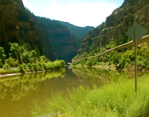
The Glenwood Canyon Trail travels about 14 miles east from Glenwood Springs through magnificent Glenwood Canyon. The trail travels alongside the Colorado River and I-70.

This is one of my favorite of the 248+ USA trails I've biked, so I stopped here briefly today to bike about 20 miles as I passed through the canyon on my way to visit the Reevers in Cedaredge, Colorado. Fortunately, luck was with me as I was able to complete the ride between rain storms.


This segment of I-70 received the 1993 "Civil Engineering Achievement" Award. Its planning, design, and construction required 22 years, $500 million dollars. An amazing tribute came from an adversary/conservationist who acknowledged after its completion that it was "A prototype for future highways in environmentally sensitive terrain."


This Interstate does not conquer the canyon, it blends into the canyon. For more photos of this lower section of the trail, see my post from last year.

Tuesday, September 7, 2010

Biking Denver's South Platte/Mary Carter Greenway Trail

The Mary Carter Greenway is an eight-mile multi-use trail and whitewater facility along the South Platte River in Arapahoe County, running from from Denver to Chatfield State Park, and it is an integral part of the central spine of the Denver Metro Area greenway system. The trail is named after Mary Hampton Carter whose vision and energy led the South Suburban Park Foundation for several critical years. It starts in Denver as seen in this map (click to enlarge)...


At Denver's south border, the trail becomes the Mary Carter Greenway Trail and runs another 8 miles along the river. A map is available on the Rails-to-Trails site here.

Here's a view of the Platte River from one of the many river crossings where the trail changes sides...


As you leave Denver, you pass industrial complexes, a brickyard, a power generating plant, a quarry or two, and an auto junkyard, but then the greenway begins and all that city stuff is left behind. You then experience numerous parks, side trails to nature areas, several golf courses, and much open space, with many views of the river and the mountains. You'll also see many man-made whitewater kayaking runs in the river, though the water level was too low to see any activity when I biked the trail.

Denver rightfully boasts of 50+ bike trails. I'm from the Chicago area, and our 5 county Chicagoland area similarly boasts 50+ bike trails, mostly running through lovely forest preserves, but none have mountains as a backdrop as seen below...


The trail has underpasses at all road crossings and signs indicate the road's name. Signs also limit speed to 15 mph though that is routinely ignored. A gravel trail parallels the Carter Trail and is used by runners, dog walkers, and horses. "Rest areas" are also abundant along the trail...


...and even Colorado's famous roundabouts or rotaries are evident where other trails connect...