Friday, July 31, 2015

2002 Sierra Club Volunteer Trail Project in Arizona's Superstition Wilderness

This Sierra Club service outing was in Arizona's Superstition Wilderness, located 40 miles east of Phoenix near Apache Junction. The area is rich in history -- from Indians (800 A.D.) to Spanish explorers (1539) to Mexicans to settlers and miners (1870s) and ranchers (1890) and military, all of which are traced in the guidebook listed at the bottom.

Its special quality was noticed early as it was declared a Forest Reserve in 1908 and was part of the original Wilderness Preservation System established in 1964. Comprised of 160,200 acres in the Tonto National Forest, it spans a distance of 24 miles by 12 miles at its widest point. Over 140 miles of trails are available. Visitors should be alert for venomous creatures such as rattlesnakes, scorpions, centipedes, brown recluse spiders, black widow spiders, tarantulas, and Gila Monsters. Vegetation includes creosote, palo verde, ironwood, cholla, jojoba, prickly pear, and the stately saguaro, and along water sources you can find sycamore, cottonwood, willow, and walnut trees. Animal life includes mule deer, mountain lions, javalina, coyote, hares, skunks, rabbits, porcupines, squirrels, rodents of various varieties, and a number of bird species.


We entered at First Water Trailhead and backpacked the eight miles or so to Charlebois Springs (pronounced by the locals as "Charley Boy.") The trails can be sand, boulder outcroppings, rocks, or combinations thereof, often with encroaching vegetation, and since most everything in the desert stings, stabs, scratches, or sticks, it is a good idea to wear long pants while hiking. Those with shorts invariably incur war wounds and may have to spend some time removing spines. Of course, wearing long pants does not guarantee an injury-free trek, as cactus spines often penetrate pants legs and still draw blood.


Below are some photos from our eight mile backpack to our base camp.


It is called the Superstition MOUNTAINS because there are mountains. In fact, the trails consist of much up and down, with the high points providing vistas in all directions. Here the trail goes up over Bull Pass. The highest point in the wilderness tops out at 6265 feet (Mound Mountain) from a low of about 1600 feet.


Weaver's Needle, a predominant land feature in this part of the Superstition Wilderness, is a weathered volcanic plug reaching 4535 feet above sea level. If you stay on the Lost Dutchman Trail instead of taking the shortcut over Bull Pass, you head right for the formation. A jumping cholla cactus is in the foreground, so named because clumps of the plant drop from it and start a new plant (or embed in your clothing and skin!)


Here we hike the Peter's Mesa Trail which takes us high above Charlebois Canyon and affords vistas in several directions. We even are able to see our camp area in the valley far below. Continuing on this trail takes you to Tortilla Well Trailhead (off the Apache 4WD Trail) but this trailhead has an extremely rough access road leading to it and is not recommended as an entry point. Steve, down on his knees, pretends to be dying of thirst, though the second photo below shows that the drought is not a laughing matter for the wildlife in the area.


Bleached bones along the trail emphasize the danger inherent in desert living. Carry plenty of water and always check with the rangers regarding current water availability in the wilderness. Water becomes crucial in the desert. Much of the wilderness lies within the Sonoran Desert and there are few reliable water sources, so check with the local ranger office before embarking on a backpack trip. Day hikers should carry all the water they will need for the day. The availability of water can vary significantly from year to year. For example, in spring of 2001, (so I was told) rainfall was plentiful, dry washes ran wet, and the desert bloomed brilliantly. In the spring of 2002, they were in a drought and water was only available in two places in the entire wilderness. So check before you hike!


Our Sierra Club Service Project Outing was an unusual one since we were not actually going to construct new trail.  We did some spot maintenance as we noticed the need, but our main mission was prevention of illegal use. Charlebois Springs is one of the few reliable year-around water sources in the Superstition Wilderness, and it is therefore a popular destination or overnight stop for backpackers and equestrians. Although no camping is ever allowed within a quarter mile of water sources in order to protect these fragile resources and to allow wildlife access to the water, this rule has been widely ignored and broken over the years, and eight or more inviting campsites (as shown below) had been etched out and enlarged in the shade of the trees adjacent to the various pools of water at the springs. Horses tied to trees had been especially destructive to the area.


Our group was assigned the job of obliterating and revegetating these areas, hopefully making them cluttered with rocks and cacti and thereby uninhabitable for overnight users. Numerous nice camp areas are available in the open canyon below the springs, and this is where visitors are supposed to camp, walking the short distance to the springs when they need to replenish water containers, or riding their horses up to give them water. The photo below is the "after" example of the same camping area pictured above. We left a trail to hike on, but filled the remaining area with boulders and rocks and hundreds of cacti which we transplanted, all of which we brought down from the mountainside. Signs were also posted informing visitors of the "no camping" rule.


How did we accomplish this transformation?  In the photo below, Gordon and I are rolling a large boulder from up on the hillside down to the work area. Behind us, Peter waits to transplant a prickly pear cactus. As we brought more boulders down from the adjacent mountainside, we naturally had to go farther away to locate even more boulders. This was heavy work, but digging up and transplanting cactus was worse, with spines in your body a natural and unavoidable consequence of the work. Several wrapped duct tape around the fingers and palms of their gloves, but many of us were still pulling spines out days after the project had ended!


Holes were dug to bury half of each boulder to make it more difficult for illegal campers to try to make room for a tent near the springs.


An interesting side note: In 2003, while sitting around our first evening's campfire with another volunteer trail crew in South Carolina, we began to get to know one another. A young married couple, both chiropractors from Canada were on their first trail project. I asked how they had learned about the American Hiking Society, and she replied that she had been searching online for outdoor volunteer opportunities and came upon a website showing a volunteer group transplanting cacti and boulders in the desert. She saw me smiling and asked why, and I admitted that she had found my website. Small world, indeed!

Jim and Young show one safe way to carry a cactus for transplanting, cleverly using the shovel handle draped through the cactus. Others carried cacti using a tarp as a sling. After transplanting, we watered each cactus, giving it more water than it has probably gotten in quite some time and hopefully increasing its chances for survival.


We also cut back encroaching vegetation ("brushing") along several miles of the Lost Dutchman Trail in both directions from the springs as we day hiked to see the area in our off-time.


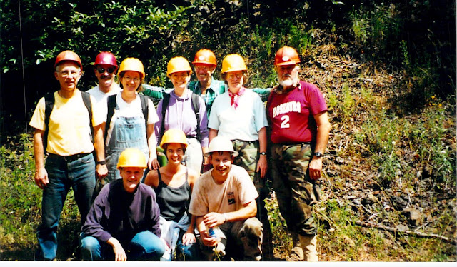
The entire, hard-working crew: 
Top row (l to r): Paul, Peter, Rita, Gordon, Chuck, Jan, Alan, Jim R., Jim I., and Judy;
Bottom row: Bruce, Steve, and Young.


Hiker's Guide to the Superstition Wilderness by Jack Carlson and Elizabeth Stewart; Clear Creek Publishing, Tempe, AZ; 1999; 319 pages.


2002 AHS Volunteer Trail Project -- Tennessee's Cumberland Trail

The Cumberland Trail is billed as Tennessee's 53rd state park and its first linear state park, traversing the rugged and beautiful Cumberland Mountains of eastern Tennessee. Envisioned in the late 1960s when work on the first sections began, the project was soon stopped. Then in 1997, the newly formed Cumberland Trail Conference resurrected the project. In 2021, the trail was 215 miles in length, well on its way to the planned 322 total miles.

Ultimately, it will run from Cumberland Gap National Park (KY) and travel through 11 Tennesee counties along the eastern escarpment of the Cumberland Plateau, ending in Signal Point National Historic Park and Prentice Cooper Wildlife Management Area near Chattanooga. It will connect three national park properties, 3 Tennessee State Parks, and 5 state natural areas. With secondary and connector trails, a total of 370 miles of recreational trails will be available. Only foot traffic is allowed on the main trail segments.

Our American Hiking Society volunteer crew met in a state park.  Several others and I had 4-wheel drive vehicles which we all piled into, and the backroads we drove really needed such vehicles. At one point our leader, Andy, made a left turn into a creek, drove up it a hundred yards, and then turned right back onto dry land. The three photos below show some of our wet driving adventures.


Eventually we reached a small clearing where we parked, and from there had to backpack our gear, food, and tools in another mile or so, including a creek we had to ford. Talk about a remote region! Then we reached the point where the trail corridor was roughed in which was the only open and flat space around, and that was where we set up base camp -- right on the trail, tent next to tent, etc. as seen below. Each day we hiked the flagged trail route over to where the trail then ended, and worked all day building new trail back towards camp.


Here are (nearest to farthest) Clyde, Jimmy, Andy (our CTC leader), Joellen, Sue, and Ray digging new trail tread which is laborious work, and the high humidity in Tennessee made it even more difficult. The temperature reached 90 degrees on several days, with humidity even higher. Staying hydrated was crucial, and I carried and drank four or more quarts of water daily, and each day, several of us would hike back to the only available spring and filter more water for everyone. All the top duff (leaves, branches, and other organic material) has to be removed so the actual trail tread will be built on solid mineral material (soil and rock.)


The next step in trail construction is seen below as Sue, Joellen, Alison, and Faith use fire rakes to smooth the new tread and remove roots to prevent new vegetation from sprouting in the trail. After this final raking, someone would get down on hands and knees with clippers to cut out any remaining roots.

In case you were curious: The orange vests and caps were required since this section of trail is in the Royal Blue Wildlife Management Area and it was turkey hunting season. Hikers are similarly required to wear orange gear during hunting seasons. To protect ourselves, we wore this orange gear whenever we were out of our tents. And yes, we did hear gunshots on occasion.


Jan, Clyde, Andy, and Ray hack out new tread on this segment of steep mountain slope. We often had to dig a foot or more into the mountainside to create a 36 inch wide trail tread, and downed tree trunks as in the photo below had to be moved to the downhill side (except on flat, wide sections of the trail where tree trunks were occasionally left to inhibit use by ATVs which are not allowed on the trail).


Here you get a better idea of what I said above -- in order to get a trail tread of three feet in width, I have to dig out a good deal of the side hill and push the soil off on the downhill side. We always left a slight tilt to the trail tread so water would run off downhill. When working with sharp tools, the crew wears long pants for protection, even though it is so hot and humid.


This typical backcountry bridge crosses Montgomery Fork of New River. Notice the stone staircase on the far side beyond the bridge beginning the uphill climb on the first of several switchbacks. Numerous stone stairways have been built to assist hikers. Though the Cumberland Trail only reaches an elevation of 3000 feet or so at its highest point, it is like a roller coaster, traveling along a ridge line, then down to cross a drainage, then up again -- over and over. The Cumberland Trail sign is visible on the tree on this side of the bridge. White paint blazes are used to mark the trail along its entire length. Remember: fires are not allowed on state scenic trails. In fact, we were not even allowed a fire while backcountry camping during construction of the trail.


This next photo shows one of my constructions on this project. The trail comes uphill and makes this 120 degree turn to the left around the tree and begins heading uphill to a section built on an old logging road. I had to make certain that rain water would stay to the right of the trail tread and not erode the trail. A pink flag can be seen in the photo toward the back. These flags were used to mark the proposed trail corridor we were to follow. I built the rock retaining wall (seen on the right side of the trail tread) to stabilize where I filled in dirt to build up the trail above the drainage level. All water will flow to the right side of the rocks and the trail will remain high and dry.


One day, Andy showed us the orange wheel seen in the photo below and asked if any of us knew what it was. Since I had coached high school cross country for 16 years, I knew it was for measuring distance. I had used ours often to check distances on new courses we were competing on and also when I was creating new courses for our home meets. So Andy gave it to me and tasked me with measuring the new trail we had built and also the trail section leading to ours from the bridge you see below, which I gladly did since I got to hike another section of the trail we hadn't been on.


Here is the entire volunteer crew: 
top row (l to r): Sue, Ray, Alison, Jimmy, Chuck, and Clyde 
seated: Joellen, Anas, and Jan  


It was great trip. The people, leadership, scenery, and camaraderie were all exceptional.  And I got to 4-wheel drive, backpack, and build trail -- all in one trip!


Thursday, July 30, 2015

2000 AHS Volunteer Trail Project for Washington's Chinook Trail Association

The Chinook Trail Association has a goal for a 300 mile rimtop loop trail circling the beautiful Columbia River Gorge through Washington and Oregon. Our American Hiking Society volunteer trail crew was based in Beacon Rock State Park on the Washington side of the Columbia River Gorge.

Beacon Rock was first described by Lewis & Clark on October 31, 1805, en route to the Pacific Ocean, marking the location where they first noticed the effects of ocean tide. Beacon Rock, like a huge pillar on the north (Washington) bank of the Columbia River about 35 miles east of Portland, Oregon, rises over 800 feet above the river level, and is one of the major landmarks in the Columbia River Gorge. Here's a photo of it...


It was bought by Henry Biddle in 1915 to save it from destruction as a quarry. He built a trail to the top in 1917-1918, quite an achievement for an individual. The trail is 4500 feet long, 4 feet wide, with a maximum grade of 15%, and has 52 hairpin turns, 22 wooden bridges, and over 100 concrete slabs, all carried up by hand or mule. The photo below gives a feel for the trail he built...


...and being hikers, one of our first requests was to make the hike/climb to the top of Beacon Rock.


In 1935, the Biddle family gave the property and 260 adjacent acres to the State of Washington. Later acquisitions made it a 4000-plus acre park, one of the larger gems in Washington's state park holdings.

The system of 300 miles of trails circumnavigating the Washington and Oregon sides of the Columbia River Gorge are the result of the volunteers of the Chinook Trail Association, a group of 150+ hard-working, dedicated citizens, and they served as our host agency and many of the members came out to meet us, hike with us, and/or work alongside us. Thanks to all! Additional trails have been added to waterfalls and to Mt. Hamilton (2445 feet above sea level), and our volunteer project worked on 2 of these other trails.

The whole crew labored on the first of two trails we worked on, the start of a reroute of the "Overlook Trail" for handicap access. Since the trail section we finished led to a rock slide and abruptly ended (to be finished later by others), we called this side trail the "Underlook Trail." Pictured from left to right: Nell, Chuck, Ralph, Bob, Bert (Bertha), Jim, Charli, Debbie, and Betty


Many huge boulders were encountered which we had to unbury and then move off the trail, some of which required much digging to uncover, and then several people on two pry bars and several others trying to muscle it out of the ground and off to the side.

The last 2 days we worked on the start of a lengthy reroute of the Hamilton Mountain Trail designed to get hikers off the old logging road and into the cooler, more scenic forest. Much of the trail we created crossed a slope ranging from 45 degrees to 60 degrees, making footing a precarious proposition. Pictured are Roger, Bob, and Jim, with the new tread becoming obvious in the dense forest.


Here is the the entire hard-working crew after the last day's work. This project was a real joy because of these fine people whose work ethic and dedication to the hiking community became evident from the first day. Ages ranged from 23 to 69 with most being in their 50s and 60s, but no one used age as an excuse to avoid contributing and all pitched in with camp chores and conversation. Commaraderie and banter predominated in camp, on our hikes, at the work sites, and each evening around the campfire.

Kneeling: (L to R): Nell, Betty, Roger
Standing: Bob, Chuck, Bert, Charli, Jim, Debbie, Ralph


We even did the jitterbug around the fire one night! It was a pleasure and priviledge getting to know these wonderful folks!


1997 AHS Volunteer Trail Project in Montana's Bob Marshall Wilderness

The crew met at the Spotted Bear Ranger Station in the Flathead National Forest of Montana, which is 55 miles south of Hungy Horse, Montana (near the West Glacier entrance to Glacier National Park.) We backpacked 8 or so miles into the Bob Marshall Wilderness carrying our own gear for 8 days of backcountry camping, and the forest service used pack stock to bring 240 pounds of food and cooking gear in three bear boxes as well as 100 pounds of tools for us to use.


"Hi ho, hi ho, it's off to work we go!" as Larry, the one on the left used to sing as we headed out each morning. We were expected to put in the same work day as Forest Service employees (8 AM to 4:30 PM) so we were up early each day and on the trail by 8 AM heading to our work site.  Each day we hiked to our assigned trail and resumed where we had left off the prior day, and when a trail was finished, we headed to another trail. Obviously, the miles hiked mounted up quickly, and over the course of our eight work days, we hiked 74 miles and cleared 15 miles of trails of 304 fallen or leaning trees (yes, I counted!) and countless encroaching bushes. We also did some spot trail retreading where necessary. Our tools were 6 foot and 4 foot crosscut saws, bow saws, Pulaskis, wedges, and loppers. Behind Larry are Chris, Herb, and Gene, our crew leader.


Below is the typical scenery we saw as we backpacked to our base camp, and also what we enjoyed as we hiked from our basecamp to our new work site every day. The contiguous Bob Marshall/Great Bear/Scapegoat Wilderness Complex comprises over 1.5 million acres and it is surrounded by another 1 million acres of national forest and BLM land, making this the largest roadless area in the country at 2.5 million acres! This ranger district is responsible for almost 1100 miles of trails within this part of the wilderness complex, so the rangers were very happy that we had arrived to help them with trail clearing. Montana has very severe winters which cause much trail damage, so clearing fallen trees and repairing trail tread is a never ending job here.


Larry, Chris, Herb, and Gene wrestle a downed tree from the uphill side to the downhill side of the trail. Snowfall melt will bring trees on the uphill side down onto the trail and necessitate being cleared the next year, so we move them now. Since the Marshall Wilderness predominantly is traveled by horse and pack stock activity, we had to clear a trail corridor which was 8 feet wide (4 feet on each side of the trail centerline) and 10 feet high. Sometimes this was easier said than done, as trees do not necessarily fall in the most opportune of locations. And on numerous occasions, there were a grouping of trees down in the same place, criss-crossed over one another. Trees with tension (or binding) on them could be particularly tricky as they tend to spring up or down as you saw through them, so care had to be taken to prevent injury. As is obvious from the photo below, hardhats and work gloves were a requirement of the job, and we were given extensive safety training by the ranger before we headed to base camp.


Gene and Herb use the two-man crosscut saw on a medium-sized tree as Chris rests after making the first cut with me. Two cuts were needed of this large log, and then we had to move the large middle section off the trail. Occasionally, on larger trees, three cuts were necessary to make pieces small enough to move off the trail. Gravity often proved to be a handy ally as we rolled pieces to the downhill slope!


The majestic South Fork of the Flathead River begins in the Marshal Wilderness and flows 40 miles through it. It made a great lunch spot when we were near it.


With the four-foot crosscut saw balanced on my shoulder, I contemplate where to make the first cut on another medium-sized downed tree. Like so many of the trees we encountered, its precarious location required finding a safe location uphill to plant my feet in order to begin sawing. After completing the inital cut, the log would fall to the trail, making the other end accessible, although the second cut often required climbing off the trail on the downhill side, again after finding a safe place to stand. The final act was to roll the cut center section off the trail on the downhill side. (Photo by Gene, our crew leader.)


Our final day was the arrival day of the crew from Public Television's long-running "This Old House" show. Here hosts Steve Thomas (seated on the right) and Norm Abrams (seated on the left) eat the cake decorated in their honor. Standing on the left is Head District Ranger Carol Eckhart, and behind the table, National Forest Service preservationist carpenter Bernie Weisgerber (red shirt) and the creator/executive producer/director of the "This Old House" and "Yankee Workshop" shows, Russ Morash. Just out of the photo was Bruce Irving, the young producer of the show for the last 8 years -- and my guess is, the one who keeps everyone on the set laughing and stress-free. The crew was here to film the work being done on an historic building deep in the wilderness. They were going to travel 33 miles into the Marshall Wilderness over two days on horses, film for a day or two, and then be rafted out down the South Fork of the Flathead River. The cake (which was decorated with a drawing of the building they were going to repair and film) followed a splendid dinner of deer, elk, moose and huckleberry products (the theme of the meal was "Made in Montana.") Fortunately, we five volunteers were graciously invited to the party.


Wednesday, July 29, 2015

1998 AHS Volunteer Trail Project in Montana's Gallatin National Forest

Repairing the Lightning Lake Trail


Yes, my Mom often told me NOT to play in the mud, but Matt (to my right), one of the Gallatin National Forest trail crew members who supervised and worked with us for the week, said this was the way to begin on the 40 foot long "turnpike" we were constructing to eliminate this very wet, boggy area. Years of use by hikers and equestrians had destroyed this low-lying area. I am digging the two-foot deep trench in which the culvert is to be buried. We are a volunteer crew affiliated with The American Hiking Society on a volunteer vacation.


We then placed logs on each side to hold the dirt/gravel trailbed, a ground cover cloth to allow water to percolate through but prevent flora to grow, and lots of dirt/gravel to serve as the trail tread. The Forest Service provided us with a Honda gas-powered wheelbarrow to carry dirt to the site from about a hundred yards away.


This is the finished turnpike, consisting of drainage ditches on each side with the culvert (foreground, under turnpike) to carry water to the drop-off side.


Our next assignment was the installation of about 18 water diversion bars, a few made with logs, but most made with rocks. A water bar is used on a downhill section of trail to divert water off the trail to the downhill side, thus preventing erosion and a wet trail.


Our final project was rerouting the trail around a lengthy low area which perenially flooded and became a mudhole. The new trail segment measured nearly 1/4 mile in length, and through arduous, consistent, work, our crew finished the entire new trail section, surprising Ron, our project coordinator for the Forest Service, and Stan, the Hebgen Lake District Ranger, who did not expect us to finish the whole re-route section when they proposed the trail project.


Working 6 hour days with Pulaskis (a combination axe and hoe), shovels, and McClouds (a type of rake and hoe) is arduous labor, especially when you are doing it at 8000 feet altitude, so we took occasional rest breaks. The ages of our volunteer crew ranged from 33 to 63, but 8 of the 10 were over 52 years of age. But the work ethic of this amazing group of people was such that age was not an inhibiting factor, but rather provided incentive to working harder, longer, and more conscientiously. And when we finished, the pride in having accomplished so much individually and collectively strengthened the bond between us.

On our afternoon off, we were treated with an 8 mile round trip hike on Lightning Lake Trail up to the lake and overlook area to see Taylor Falls.


We forded the Taylor Fork River on the way up, and 40 minutes later, on our return trip back to camp, one of our earlier fresh boot marks in the muddy shore had a fresh impression of a grizzly claw on top of it. We talked very loudly on the rest of the hike so any nearby grizz would know we were coming and wouldn't be startled!


Here's the entire crew. Back row: Jon (a welder/assembler from Iowa, the youngest on our AHS crew), me, Steve (a retired Forest Service forester), Bill (Forest Service trail crew leader), Jim (a retired Lieutenant Colonel and currently an ROTC instructor in Arkansas), Chuck (retired lawyer/engineer with the United States EPA from Maryland) and Martin (a retired urologist from Arizona).

Front row: Matt (Forest Service crew and student at Montana State University), Deborah (our AHS crew leader and our cook, a director/educator from Iowa), Victoria (an early childhood special education teacher from Iowa), and Sue (a tax preparer, married to Jim, from Arkansas).


(Not pictured due to an accident which required hospital care is Sam, student at the University of Oregon, the third National Forest trail crew member, whose wit, antics, and joy for life entertained us for 4 days and whom we all greatly missed the last few days of our project. Get well quickly and completely, Sam!)

2001 AHS Volunteer Trail Project - Colorado Trail

In 1987, the Colorado Trail Foundation was established. The Colorado Trail now stretches from Denver to Durango with over 500 miles of trail through seven national forests, six wilderness areas, and across eight mountain ranges, traveling through ecosystems from Plains to Alpine. Its altitude ranges from 5520 to 13,271 feet above sea level and much is above 10,000 feet. In fact, it averages 10,300 feet. Most of the trail has grades of 10% or less. Numerous 14ers are accessible from the trail. Camping is allowed on public land. The trail is open to hikers, backpackers, equestrians, runners, llama trekkers, and except in wilderness areas, mountain bikers.

In 2001 I was part of the American Hiking Society crew that helped reroute the Colorado Trail around Copper Mountain Resort (Colorado Trail section #8) high up across the ski slopes. The trail had previously descended to the town and then climbed back up at the other end of the town.

We drove up access roads and set up camp at the T-Rex Grill at an elevation of about 10,600 feet, and since many of our crew are from flatland areas, the work was rather arduous. Our crew was about half AHS volunteers and half teenagers from our leader's church youth group. I've done 30 of these volunteer trail projects over the years and it's usually middle age and retired folks on the crew. It was fun working with the youngsters!


Digging out the initial tread is arduous work, and Rich (front), Jim (left), and Rob work at it here using Pulaski and McCloud tools. This new trail reroute will allow Colorado Trail users to avoid the main street of Copper Mountain Resort, taking them across the mountainside south of the resort instead, through beautiful forests and across meadows (which are in fact ski slopes during the winter). Though the ski resort leases the mountainside for its operations, the land is controlled by the U. S. Forest Service which diligently oversees all trail and bridge placements.


After the initial trail tread is established, it must be further dug out, smoothed, and leveled, as is being done here by Michelle, Becky, Matt, Rich, Ken, Andy, and Rusty. The "duff" or organic material resting atop the surface will not support a trail, so it must be dug out and moved to the downhill side of the trail, leaving mineral matter (soil) as the trail base. Sometimes the duff is 8 or more inches in depth, requiring removal of a great amount of organic material.


Jan, Ann, Jessi, Nancy, and Nate work on another section of trail. The scenery is magnificent, and at this altitude, insects were rarely a problem.


Tony is not excavating for oil here. A large buried boulder has to be dug out and removed from the tread, and behind him you see other such rocks already removed from the trail. Large roots and stumps sometimes had to be removed, too. On the trail behind him is a long, thin, but sturdy rock bar (or pry bar) he will use to pry out the boulder after it is partially unearthed. Sometimes a group of people have to combine efforts to budge the boulder out of the hole.


Below you see the finished trail crossing a meadow, which actually is a ski slope for Copper Mountain Resort in the winter. Beyond that, is another section of forest. Few skiers ever see this area in all its verdant summer glory, and next winter, the skiers will be unaware of a trail below the many feet of snow upon which they are skiing.


Below is one of the forested areas which now has a beautiful trail through it.


The trail also crossed several small creeks and wetland areas. and the forest service demands that these fragile water features are protected from overuse.  That of course requires the construction of bridges which was the portion of the project that I was primarily involved with.

First we had to lop off bushes to allow construction of a bridge to span this small creek/wetland area. Hikers, equestrians, and mountain bikers would destroy the area if the bridge were not present to take them over the fragile area.

The sills at each end of the bridge have already been leveled and have had a hole drilled in each end to allow a 3 foot length of rebar (steel reinforcing bar) to be hammered through the sill and into the earth to anchor the sill in place. Boulders were then placed on and around the sills for additional stability.

Nate is taking his turn at cutting the notch for the second stringer to sit on the sill as his father, Rich, (seated) watches. Standing are Dave and Gene. You might notice how yellow the pieces of timber look. Gene and I debarked all the pieces as the first step in the process.


I take my turn hand drilling holes through the stringer and sill in preparation for the rebar that will be driven through both pieces of timber and into the soil. This view shows the bridge taking shape and the early work on the approaches to both sides of the bridge. Dozens of large boulders eventually had to be carried to the site and used to reinforce the sills and also to create a retaining wall to hold the hundred plus buckets of soil dug out of the mountainside and carried to the site to elevate the trail tread to the height of the bridge decking.


The finished project! Water bars and drainage swales were added on both approaches to prevent heavy runoff from eroding the earthwork and tread, and boulders were strategically placed to reinforce the bridge during heavy spring meltoff conditions. Since the existing bushes were merely lopped off, all will regrow and fill in closer to the bridge with no permanent damage having been incurred by the wetlands area. You can also see how we raised the level of the trail up to the bridge top to protect the wetlands and make for a smooth transition from trail to bridge.


Here is our dedicated and hardworking volunteer trail crew:


Standing: (l to r) Rich R., Glenn, Dave, Anne, Matt, Tony, Rich K., Jim, Gene, Andy, Rob, Nate, Ken,  Ray, and Rusty
Seated: Sherry, Sandy, Jan, Becky, Michelle, Jessi, and Nancy


FOR MORE INFO:
  
The Colorado Trail Foundation
710 10th Street
Suite 210
Golden, CO 80401-5843
(303) 384-3729
  
Colorado Trail Foundation website